Schatzberg loop hike
The hike is graded as demanding based on the it's length leading along forest tracks, mountain trails and through Alpine pastures.
Starting from the village centre walk past to the right of the church, past the Hotel Alpbacherhof and turn left at the bridge onto the "Mühlbach" path. Follow the A3 signs to a bridge, cross the bridge and follow the signs for "Heimatweg", at the Kneipp facility follow the signs for "Blaiksteg" Hösl Saddle.
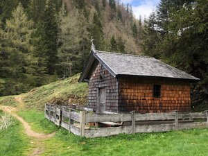
At the Hösl chapel bear right and follow the "Thalerkögl - Schatzberg" signs. One passes the old and new Höslalm and the forest track becomes a trail leading up to the Schatzbergalm (approx. 2 h 30 min). The climb from here to the peak cross at 1.898 m takes approx. 30 min. Immeadiately below the peak is the Gipföhit (a further mountain restaurant).
For the walk back take either the A28 from the Alpbach/Wildschönau new connecting lifts top station or walk back via the "Schatzberglacke" (pond) and the "Alpenrosenweg" down to the "Wurmeggalm". Both paths merge and continue to the "Pechalm" and the "Alpengasthof Rossmoos". Take the "Oberer Höhenweg" down to Alpbach; either along the A3 or on the tarmacked road.
Details
| Max. Altitude | 1898 |
| Start | Alpbach village centre |
| End | Alpbach village centre |
| Public access | A12, motorway exit Kramsach/Brixlegg, towards Brixlegg, Alpbachtal, Alpbach village centre |
| Public transport | www.vvt.at, bus no. 620 |
| Parking | entrance to the village |
| Equipment | Sturdy shoes, protective clothing |


